Hiking At Ricketts Glen
|
Safety Reminders
|
|
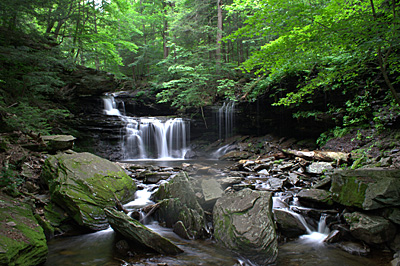
Ricketts Glen has 26 mile of beautiful hiking trails that vary from level to very steep and are the prime attraction to the park.
Falls Trail: 7.2 miles, most difficult hiking The full loop of this trail is 7.2 miles if hiking both the upper and lower sections. To see most of the waterfalls, a 3.2-mile loop can be taken by going on Highland Trail and the Glen Leigh and Ganoga Glen sides of the trail. The trails follow along 21 beautiful waterfalls ranging in heights from 11 feet to 94 feet. The scenery is well worth the effort, however, the terrain is rocky, can be slippery, and descends steeply on both the Ganoga and Glen Leigh sides. Hikers should take extra precautions with trail conditions, wear proper footwear, stay on the trail, and be in good physical condition. The Falls Trail is closed in the winter except for properly equipped ice climbers and hikers. Beach Trail: 0.8-mile, easiest hiking Campers in both camping areas can access the Lake Jean day-use and swimming areas without having to travel on a road. Cherry Run Trail: 4.6 miles, more difficult hiking Near the Lake Leigh dam is access to Cherry Run Trail, where hikers will pass through groves of cherry trees and view evidence of the old logging railroads that passed through this area over 100 years ago. Hikers can connect to Mountain Springs Trail by walking 3.5-miles on Mountain Springs Road. Evergreen Trail: 1 mile, easiest hiking Self-guiding tours take visitors into old growth forest, one of the few stands remaining in all of Pennsylvania. Hikers can see a hemlock that stood on this continent before Columbus. This is an easy, 1 mile hike into the past. Ganoga View Trail: 2.8 miles, more difficult hiking Named after the park’s highest waterfall, this trail allows hikers to walk up to the side of Ganoga Falls without having to hike the Falls Trail. Although the trail is easy to moderate hiking, use caution where it meets Falls Trail due to the switchbacks and drop-offs. Ganoga View along with the Old Beaver Dam Road Trail makes an excellent loop trail for hikers and cross-country skiers. Grand View Trail: 1.9-miles, more difficult hiking This trail takes hikers to the highest point on Red Rock Mountain (elevation 2,449 ft). In mid-June, the beautiful mountain laurel is in bloom. The best view is during the limited time that the fire tower is open (fire season in the spring and fall). In mid-July, the high bush blueberries bear fruit, and in the fall, there are awe inspiring views of the fall foliage encompassing the surrounding hillsides, making this trail a pleasant hike at any time of the year. Highland Trail: 1.2-miles, more difficult hiking The trail cuts across the top of the Falls Trail and crosses through Midway Crevasse, a narrow passageway between large blocks of Pocono sandstone conglomerates that were deposited throughout this area by glacial movements. At least three times in the last one million years, continental glaciers buried this land under hundreds of feet of ice. This trail makes an excellent area for geological study groups. Mountain Springs Trail: 4 miles, more difficult hiking Heading off of the beaten path, this trail takes hikers on a 4-mile hike passed the old Lake Leigh Dam, the forgotten falls, and down the south branch of Bowmans Creek to the serene Mountain Springs Lake area. Hikers can connect to Cherry Run Trail by walking 3.5-miles on Mountain Springs Road. Old Beaver Dam Road Trail: 1.2-miles, more difficult hiking Named for the old beaver dam that can be seen just off the trail, this trail makes an excellent loop trail for hikers and cross-country skiers. Access is from a small pull-off of PA 487, or from the Lake Rose parking lot. Old Bulldozer Road Trail: 2.9 miles, most difficult hiking With its unique name (once used by a bulldozer to get to the top of the mountain to build the park), comes quite an elevation change. Accessed from the parking lot on PA 118, this trail is used by hikers and snowmobilers to access Mountain Springs Trail. Although most of the trail is easy to moderate hiking, a short section just up from the bottom is very steep. The Bear Walk Trail: 1 mile, easiest hiking Walk the trail of the bears - this short trail accesses other trails for cross-country skiing, snowmobiling and hiking. It runs from the entrance of the cabin area to Lake Rose. Horseback Riding:12.5-mile loop Horse riders may enjoy taking a 12.5-mile loop by riding the Cherry Run Trail, Fish Commission Road, and Mountain Springs Trail. Sights to see include: old railroad grades, Mountain Springs Lake (formerly used to make ice), and an old concrete dam once used to hold back Lake Leigh (now a dry lake). Riders must bring their own mounts. Horses cannot be rented. |
Hikers on the Falls Trail should be in good physical condition, wear sturdy boots, and use caution due to slippery/wet conditions and steep trail sections. The following guidelines will help ensure a safe and enjoyable hiking experience while at the park.
Resources
|
||||
